How do school catchment areas work?
So, you’ve been researching the schools in your area, you’ve had a look around on an open day and you know where you’d like your kids to go, but what are your chances of getting in?
For a lot of schools, where you live will be the biggest factor in whether your child will get in. Of course, for religious and selective schools there are other more important factors, but where you live can still play a part.
For most schools, to understand your chances of getting in, you need to understand catchment areas. In this post we explain how catchment areas work: what they are, what they are not, and all the different ways in which they work in different parts of England.
This is all based on our work recording and visualising catchment areas across England over the last 5 years in this website, to help parents and house-hunters understand their chances of getting in.
What is a catchment area?
The first thing to know about catchment areas is that there actually isn’t any such thing as an area where, if you live in it, you’re 100% guaranteed a place (sometimes a small school might fill all its spaces solely with siblings of existing pupils).
In fact, the area a school admits children from changes from year to year, getting smaller or bigger based on who applies.
When a school decides who to offer places to, in general, they will admit siblings first and then the rest are admitted based on where they live, religious and selective schools aside.
This can happen in a number of different ways:
- Often it’s just based on how far away they live as measured in a straight line
- Sometimes it’s measured by walking distance
- Sometimes schools prioritise children for whom the school is their nearest school
- And sometimes schools have priority admission areas that they use to prioritise children who live in a specific neighbourhood.
And, inevitably, there are schools that try and combine all of these together into an incomprehensible mix that make it almost impossible to understand your chances of getting in!
I’m now going to take you through each of these methods in more detail, with examples, to explain how they work.
Straight line distance catchment
What is it?
A straight line distance catchment is a circular catchment area around a school that changes each year. The size of the circle is determined by how far away the last child offered a place that year lived from the school.
How does it work?
When used by itself, this is probably the simplest method to understand. If a school has 30 places left after other places were offered, they rank the remaining applicants by how far away they live from the school as the crow flies and the nearest 30 get offered places.
The distance that the last pupil offered a place lived from the school then determines the effective catchment area in that year: if you’d lived closer than that distance, you’d have been offered a place in that year.
So, draw a line between your house and a school, compare this to the last distance offered in previous years, and you start to get a good idea of your chances of getting in (although bear in mind that a bumper crop of local siblings in a future year can have a big impact, see the example for Henry Cavendish school).
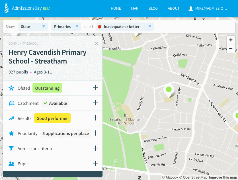
Henry Cavendish School, Streatham
In 2018, 18 of Henry Cavendish’s 60 places were given to siblings of existing pupils. The remaining 42 places were given to the pupils living nearest the school, with the last place being offered to someone living 0.55 miles from the school. This determined the catchment area for the school in that year.
In 2019, the number of places going to siblings went up by over 50% to 30: half the places the school had to offer. The last pupil offered one of 30 or so places remaining lived 0.25 miles from the school: a catchment area less than a quarter the size of the one the year before.
When and where is it used?
Straight line distance catchments tend to be used on their own (without priority areas) in urban areas where schools are closer together and people tend to be more uniformly spread than in rural areas. Examples include the majority of greater London (although some boroughs do things differently), Manchester, Birmingham and Bristol.
Walking distance catchment
What is it?
A walking distance catchment is an irregular shape that changes each year. It is partly defined by the network of roads and paths that surrounds a school and partly by how far away the last child offered place in a given year lived from the school.
How does it work?
It works in almost exactly the same way as a straight line distance catchment, except that applicants are ranked by how far away they live measured along a walking route.
It gets more complicated than straight line distance because the exact walking route is selected by a council mapping system, and they often say the shortest “safe” walking route and sometimes “safe, lit” walking route. This can be hard to measure for yourself if you’re not in the habit of keeping a record of the location of streetlights.
We try and help with this by automatically plotting shortest walking routes on the map for schools that use them, but we can’t be sure we’re using the same routes as a local authority would do.
When and where is it used?
There aren’t many local authorities that use them, but examples include Richmond-upon-Thames and Newham in London and Medway council in the South East.
Some individual schools such as Julian’s Primary in Lambeth also use walking distance.
Priority admission area
What is it?
Some schools prioritise admissions from a fixed geographical area, often called a priority admission area (PAA). They first admit applicants from within the area, and then applicants from outside it.
The shape of their catchment in a particular year is actually a combination of the PAA and a distance catchment. The nature of the combination depends on which rules applicants were admitted under. Read on for more ...
How does it work?
If a school with a PAA has more applications than places, then it will, usually, first admit children living within the PAA, normally starting with siblings. Once all children within the PAA have been offered places, then the remaining places will be offered to children living outside the PAA. Again, this normally starts with siblings before moving on to other children.
The order of priority within these categories is normally determined by how far away from the school the pupils lived, which is normally measured by straight line distance.
So, this can lead to a few different scenarios for the catchment in that year:
- Catchment smaller than PAA: if there are a lot of applications from children within the PAA, then sometimes not everyone living in the PAA gets in. When this happens, the catchment area in that year is the overlap of the PAA and a straight line distance catchment as described above.
- Catchment equivalent to PAA: it occasionally happens that all children within the PAA are offered places, but no one from outside is. In these situations, the catchment is equivalent to the PAA.
- Catchment larger than PAA: if every child in the PAA is offered a place and children from outside are then offered places, the PAA is the combination of the PAA and a straight line distance as described above.
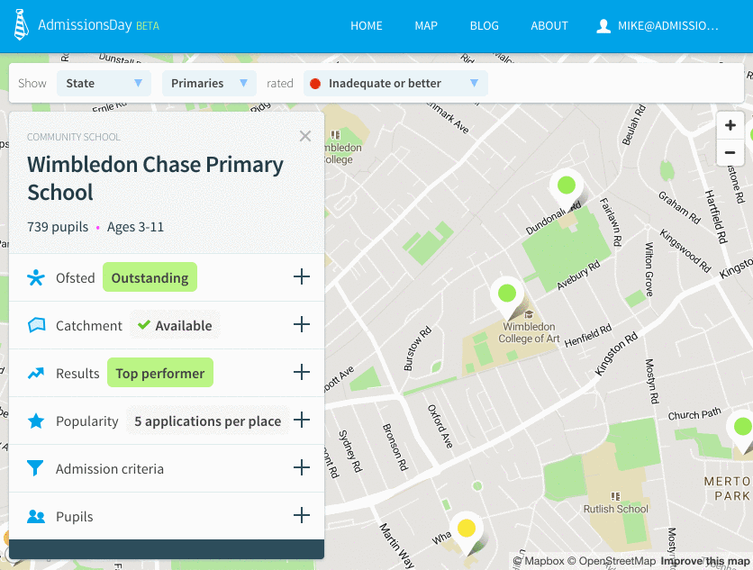
The example below shows how Wimbledon Chase Primary School’s catchment has stayed resolutely within its priority admission area for a number of years:
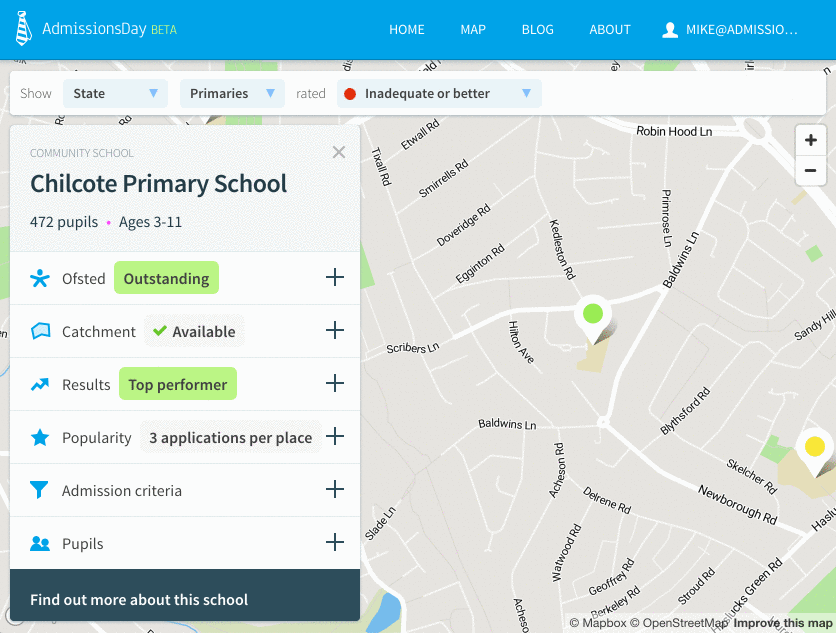
Whereas Chilcote Primary School in Birmingham has typically admitted pupils from outside its priority admission area:
When and where is it used?
Priority admission areas tend to be used in more rural areas where school location is less uniform and the education authority wants to connect particular schools with particular areas. They can also sometimes be used for a few years after a school is first created to ensure that the school prioritises the local community.
Nearest school priority area
What is it?
Nearest school priority areas are a kind of PAA that arise from a particular admission criteria that some areas use: they prioritise applicants for whom a school is their nearest school.
As with schools that have a PAA, the shape of their catchment in a particular year is then a combination of the PAA and a distance catchment.
How does it work?
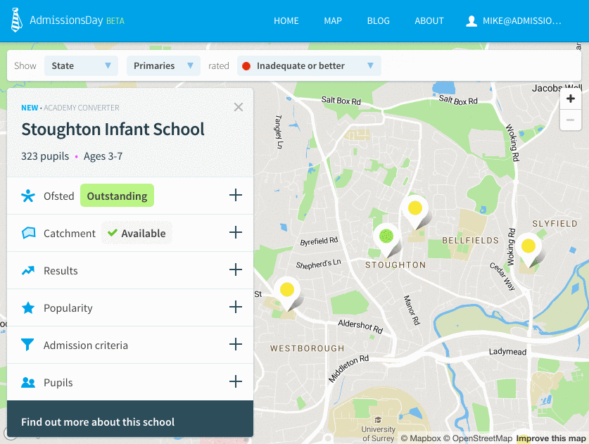
Prioritising applications that are made to their nearest school leads to a carving up of the space in an area into shapes defined by the locations of the schools themselves. The image below shows how that works for an area of Surrey.

In theory this is a simple, easy to understand mechanism for prioritising local applications, but in reality, not every school in an area is always included in a scheme like this, which can get very confusing for parents trying to understand their chances of getting in.
As with PAAs, applications are prioritised initially for children within this nearest school area and then outside, which leads to the same catchment area scenarios as are described above for PAAs.
When and where is it used?
Nearest school priority areas tend to be used in more urban or suburban areas where local authorities want to keep schools focused on a local area, and where population tends to be more evenly spread.
Areas that use this approach include Leeds City Council, Hertfordshire County Council and Surrey County Council.
The end.
So, school catchment areas: more complicated than you might have thought. Of course most people only have to try and understand one of these approaches for the area they live in.
And if you need help, we’re on a mission to capture, model and visualise all of this data in AdmissionsDay.co.uk.
Check it out, and see if we have data in your area, by searching below.
Explore school admissions and catchments near you
Enter a postcode, street or town to get started